ODAGIS+
CORPORATE GIS PLATFORM

ODAKENT® ODAGIS+ ™ is an advanced infrastructure, environment and city management solution based on geographic information system that enables you to access maps and information required for planning, manufacturing, operation and emergency management activities in a central and secure manner.
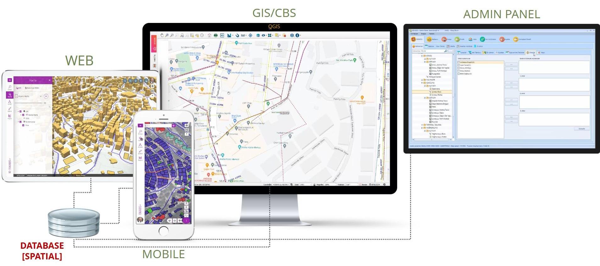
ODAGIS+ is also the general name of the solution package and includes 4 different products:
ODAGIS +Desktop
ODAGIS + Web/Mobile
ODAGIS + Admin Panel
ODAGIS + AsBuilt
ODAGIS+ is a desktop application that can run on all commonly used operating systems, and it works with a geodatabase connection on the open source QGIS platform. ODAGIS+ Web/Mobile applications are web-based applications and can broadcast online/offline over Spatial database. Odakent ODAGIS+ software offers a powerful and modular solution that integrates desktop and web and mobile applications, integrating CAD, GIS, maps, infrastructure/superstructure facilities and customer information.
Open, Flexible, Modular Architecture
Odakent ODAGIS+, urban infrastructure and environmental management model software, has an architecture that keeps information in open format in geodatabase in accordance with Open Geospatial Consortium (OGC) standards. Keeping the data in open spatial format brings the flexibility to work with any CAD or GIS software.
ODAGIS+ is a software with standard data entry and update modules for urban infrastructure components such as natural gas, electricity, water, wastewater, storm water, telecom facilities and address management. Standard data entry and update interfaces in each module bring ease of use. These interfaces support standard database structures, workflows and rule definitions for data entry with high location precision.
Single Data Source
At the center of Odakent ODAGIS+ urban infrastructure and environment integrated management system, there is "spatial-geographical" database technology. Vector and verbal information of all infrastructure and superstructure assets are kept in the spatial database. In this way, it is possible to access information quickly and safely without generating unnecessary data, without format conversion, and without encountering obstacles.

User Friendly Interface Design
ODAGIS+ has a patented user interface that provides access to data entry, update, reporting, analysis functions of all infrastructure and superstructure assets on an additional main form.
In addition, the standard Add / Edit / Delete functions design in all data entry and update modules enable users to adapt to the software very quickly.
Powerful Map Management System Support
ODAGIS+ can geographically archive, manage and present thousands of maps of different dates and scales to users in a very easy way. It can also use thousands of Web Maps published by Open data sources as a base.
Infrastructure-Specific Data Models, Workflows and Rules
ODAGIS+ offers template interfaces specific to each infrastructure related to the management of assets belonging to wastewater, storm water, natural gas, electricity, telecom networks.
Functional Management Interface
Web/mobile broadcasts can be managed through the management interface. In addition, access and integration processes to different databases of the institution can be done in a standard way. Interfaces are provided to manage periodic data update operations between databases.
It is possible to display the information in the information forms as desired by matching the information in the relational tables with the admin interface and arranging the order.
User Based Authorization
Data entry, update, usage, etc. can be provided to each user from the admin interface on the basis of layers, maps, saved queries and reports. authorizations can be granted. Likewise, all kinds of viewing and editing authorization settings and function usage authorizations can be made on a user basis.


Ultimate Security
Odakent ODAGIS+ software keeps the changes made separately from the existing information and initiates an approval mechanism for the completion of the process, and as a result of the approval process, the data takes its final form. In addition, all kinds of updates are recorded, and when the information of the object is received, the changes made on an object basis can be easily monitored. This function provides high security for your information. In addition, the changes made can be undone on a user basis.
Performance Tracking
All kinds of data generation and updating works performed by the users can be reported as tables and graphics within the desired date range from the administrative interface, and their performance can be monitored.
Spatial Document Management
With the Spatial Document Management Tool, all documents (video, picture, office, CAD, etc.) can be associated with infrastructure and superstructure objects and stored in the database or hard disk. These documents can be easily accessed by querying spatial or other information when requested.
Integrated Web Access and Mobile Applications
ODAGIS+ Web/Mobile is a standard and integrated component of desktop GIS software. This feature allows non-technical users or administrators to easily access map information, reports and analysis results via the web interface. Since ODAGIS+ Web uses the same data source as the desktop GIS interface, the changes made can be viewed instantly in this interface.
It offers easy-to-use and flexible interfaces to be used on mobile devices, which will facilitate your data collection and verification studies, especially in the field.
Powerful Analysis Support
ODAGIS+ automatically keeps up-to-date and repairs the topological information of networks belonging to infrastructure facilities. Network analysis and monitoring of the network can be done easily, since it is working on a model in which the network lines are directly connected to the buildings. The topology is updated automatically when new infrastructure and superstructure facilities are added.

Address, Customer and Other Information Systems Integration
Especially for local governments and infrastructure organizations, customer/citizen information is of great importance. ODAGIS+ software includes very easy-to-use interfaces that will enable the integration of the geographical address information system, which it has created within itself, with the National Address Database (UAVT) and the Customer Information System.
It also provides integration support to different databases used in the institution for SCADA and Management Information Systems integration directly or via web services.
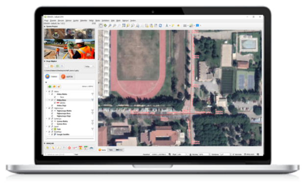
AsBuilt Projects Preparation Tool
An important difference of ODAGIS+ software from other GIS software is that it offers a ready-made tool where information can be entered into a special geodatabase file for the preparation of end-of-work projects (AsBuilt) after infrastructure fabrication in the field. Thanks to this tool, asbuilt projects are prepared as GIS data and can be directly transferred to the spatial database.
Geo Messaging Tool
Thanks to the patented Odakent technology, users can communicate with each other by sending coordinated drawing objects and messages through the database within the ODAGIS+ GIS platform.