"CORPORATE" GEOGRAPHIC INFORMATION SYSTEM SOLUTION
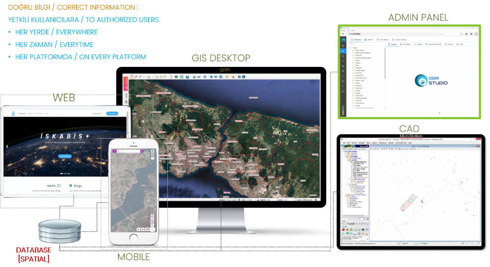
It is a new generation (no-code) GIS solution package that is highly secure, easy to use and manage, desktop, web, mobile integrated new generation (no-code) GIS solution package where information and related documents of all corporate infrastructure and superstructure facilities can be managed around a centralized, spatial plug-in database.
"ENTERPRISE" RESOURCE PLANNING SOLUTION
It is a new generation (no-code) Enterprise Resource Planning (ERP) solution package with high security, easy to use and manage, web and mobile integrated, where all corporate business applications can be developed and managed in a modular structure around a central database.
PLANNING, PROJECTING, MODELING SOLUTION
It is a solution that includes advanced Infrastructure and Superstructure Planning, Projecting, Modeling, Analysis, Reporting and outputting tools running on QGIS Desktop Geographic Information System software, which can use online map resources as a base that planners need.
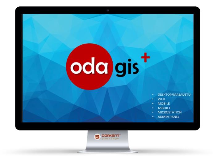
[ 1 ] ODAGIS+ SOLUTION PACKAGE
Turkey's 20+ years of "Corporate GIS" Experience: ODAGIS+
ODAGIS+
Reflecting Turkey's 20+ years of experience, Corporate GIS solution is now at your service as a software package.
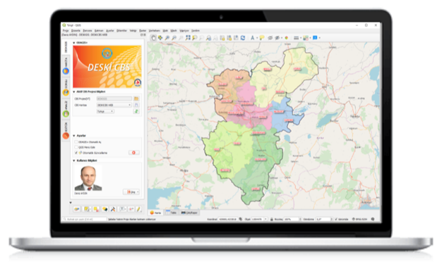
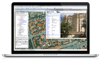
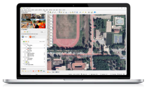
Corporate Desktop GIS Software
ODAGIS+ QGIS
It is a fast, easy-to-use and easy-to-manage corporate desktop software running on the open source QGIS 3.x platform with advanced geographic information system functions.
The program works in connection with the central geographic database and is based on user authorization, approval and tracking mechanisms, which are indispensable for the corporate structure. In addition, the program provides functional interfaces for data generation, updating, analysis and reporting.

Desktop CAD/GIS Software
ODAGIS+ MicroStation
It has been developed especially for planners and project managers working on map-based applications. Today, CAD programs are overwhelmingly used in the design of infrastructure and superstructure facilities, and the need for the integration of these programs into GIS is met by this software. Not only MicroStation, but also ODAGIS+ integration for other CAD software can be done with ODA-KEYS technology.
Desktop Admin Panel Software
ODASTUDIO
ODAGIS+ Administrator Panel is an interface software where even non-IT personnel can perform basic database management functions, manage authorizations, reports and business rules.
With the Admin Panel, the information in the relational tables can be matched and sorted, and information forms can be displayed as desired. From the admin interface, each user can be authorized to access and edit geographic layers, maps, saved queries and reports. Likewise, all kinds of data display, generation and update authorization settings, function usage authorizations can be made on a user basis. From the admin interface, all kinds of data generation and update activities performed by users can be reported as tables and graphs in the desired date range, and their performance can be monitored.

Asbuilt(End-of-Work) Projects Preparation Software
ODAGIS+ AsBuilt
It is a ready-to-use software where information can be entered into a special geographic database file for the preparation of end-of-work projects (AsBuilt) for infrastructure and superstructure facilities manufactured in the field.
Thanks to this software, end-of-work projects can be easily prepared as GIS data in accordance with the standards and transferred to the central geographical database. This software is of great importance for the continuity and sustainability of the system.
Web/Mobile Web Software
Corporate GIS Integrated Web Map Software
ODAGIS+ Web
ODAGIS+ is a software that enables maps prepared in desktop GIS software to be published on the web in the same visual and fast way. Users are provided with easy-to-use and functional web-based interfaces for use on mobile devices, which will facilitate data collection and verification especially in the field.
In addition to map publications, the Business Intelligence (BI) interface embedded in the system is presented to users in a decision support system format as standard "tables, graphics and thematic maps". The prominent features of the product are as follows:
• Automatically adjusted interface design suitable for desktop web, mobile devices (Responsive Design)
• Dynamic query interfaces based on user authorizations, rule-defined data entry and update functions
• Optional support for different languages and display styles
• Global view with digital terrain model without the need for plug-ins, view 3D objects

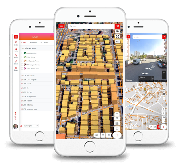
Corporate GIS Integrated Mobile Map Software
ODAGIS+ Mobile
Since the ODAGIS+ Web interface has a "dynamic/responsive" design, it can be successfully displayed on mobile devices such as tablets and smartphones.
However, the web interface was optimized and a different mobile interface was redesigned and put into use. All the functionality on the web is offered exactly in the online mobile interface.
Corporate GIS Web Map Portal Software
ODAGIS+ Atlas
ODAGIS+ is a software that enables the maps prepared in desktop GIS software to be opened safely and quickly to external users (public) with the same visuality. It offers high-performance, high-security, easy-to-use and functional interfaces designed especially for city guide, corporate map services, etc. needs.
In addition to map publications, the Business Intelligence (BI) interface embedded in the system is presented to users in a decision support system format as standard "table, graphic and thematic maps". Highlights of the product are:
• Automatically adjusted interface design suitable for all desktop web and mobile devices (Responsive Design)
• High display and query performance
• High security infrastructure
• Support for adding new maps, queries, graphics from the Administration Panel
Corporate GIS Integrated Site Mobile Map Software
ODAGIS+ FieldMobile
ODAGIS+ FieldMobile is a field data collection/update application of Odakent AŞ, developed on the android operating system and published on Google Play. The application has been developed with React Native software and can work hybrid (online/offline synchronized). Institutions that have this application can create jobs and teams on their corporate GIS with the help of the Admin Panel, and can automatically direct the work to the teams from the center. Users registered in the system can process the work orders coming to their mobile device as field measurements on point, line, polygon layers and send this data back to the central database.

Integrated Relational Database Management System
ODA-KEYS
It is the Geographical Relational Database Management system developed by Odakent. The most important feature of the ODAGIS+ solution is that, in addition to having an advanced GIS-based infrastructure, it has a strong "City, Infrastructure and Environment-Integrated Management System" that it works on in the background. It has the ability to run different desktop (CAD / GIS), web and mobile software together, thanks to a C-based extension (extension) developed within this system and running on the database.
This system is an "Open, Modular, High Security, Integrated, Flexible, Scalable" system that has been created and tested with real corporate experiences over the years and has an award-winning design. One of the most important features of the system is that it has a strong geographical address information system and can work in integration with the customer information system and other information systems of the institution.
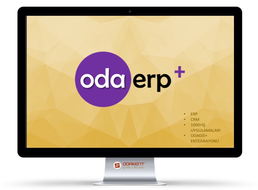
[2] ODAERP+ SOLUTION PACKAGE
Web Based Business Applications:
- Practical Development Tools
Creating or editing web applications is done from the web browser using drag-and-drop techniques or simple settings screens. Usage difficulties arising from different non-standard designed interfaces are eliminated.
- Better Utilization of Human Resources
Without being dependent on the Developer to make customizations on existing views; It is ensured that the design, development, maintenance and support activities of the applications can be carried out by field/field experts besides the expert software developer.
- High Security
Injection Flaws listed by Open Web Application Security Project (OWASP), Cross Site Scripting (XSS), Insecure Cryptographic Storage, Insecure Communication, URL Access Restriction Failure, etc. Designed to prevent the most common vulnerabilities for web applications
- CBS / Akıllı Harita Entegrasyonu
ODAGIS+ Masaüstü, Web/Mobil kurumsal Coğrafi Bilgi Sistemi platformu ile tam entegre bir çözümle çalışma ortamı sunulmaktadır.
- Kullanıcı Dostu Arayüzler
Yazılım geliştirme, mevcut yazılımların bakımı ve entegrasyonundan sorumlu birimlerin yöneticileri, proje yöneticileri, yazılımcılar ve teknik personeller için oldukça pratik ve kullanışlı arayüzler sunulmaktadır.
- Yüksek Kalite, Düşük Maliyet
Hızlı Web Uygulaması Geliştirme çözümü ile bağımlılıkları ve maliyetleri azaltan, yüksek kalite ve sürdürülebilirliği sağlayan ideal bir çözümdür.
Water Loss Management System Software
ODA+ WaLMS
ODA+WaLMS is a web-based Water Loss Management System application. Institutions that have this application can monitor their drinking water losses and use them as a decision support system by enabling the GIS, Subscriber, SCADA and Fault Tracking databases to work simultaneously with each other with the help of the Admin Panel on their corporate GIS.

Spatial Asset Management System Software
ODA+ MVYS Tracking module is a Web-based Spatial Asset Management System application. Institutions that have this application can create a spatial inventory of all real estate assets within a system, fully integrated with their corporate GIS, and can easily monitor and manage processes such as maintenance and repair.

AsBuilt Projects Management System Software
ODA+ APMS
ODA+ Asbuilt Projects Management module is a web-based, End-of-Work/AsBuilt Projects Management System application. It is a monitoring system software that securely manages the processes of entering the system by the Contractor, who produces the end-of-work projects in full integration with their corporate GIS, and controlling the processes by the Construction, Map and GIS teams on the institution
Work and Team Management System Software
ODA+ WTMS
ODA+ İEYS module is a web-based corporate Business and Team Management System application. Institutions that have this application can monitor their teams in the field and the works carried out in full integration with their corporate GIS, and can present this information to the relevant units simultaneously.
[3] ODAPLAN+SOLUTION PACKAGE
Planning, Projecting, Modeling and Simulation Software
are developed for you...
It is developed to meet the needs of technical personnel working in the Planning and Projecting sector. It is a solution package that includes powerful data entry, updating, analysis and reporting tools running on open source QGIS software.
In the solution package
- Drinking Water Hydraulic and Water Quality Modeling (EPANET)
- Wastewater, Stormwater Hydraulic and Hydrological Modeling (SWMM) modules are planned.